Department of Surveying and Geodesy
The department offers undergraduate programs in: "Geospatial Digital Engineering (Geodesy)", "Land Management & Cadastre" and "Surveying". Additionally, it offers master's programs in "Geospatial Digital Engineering", "Land Management", and "Surveying", as well as doctoral studies in the field of "Geospatial Digital Engineering". We also have English-language programs available to help students expand their opportunities and attract foreign students.
Our goals and objectives in the field of education are:
- Organizing the educational process for both basic and advanced engineering and technical programs
- Developing professional and cultural skills among our graduates that are in high demand in the Kazakhstani labor market. The department sees the prospects for its development in line with the university's 2022-2026 strategy. The main objectives of the department are:
- Strengthening the material base by creating modern educational, scientific, and production laboratories through the purchase of sufficient quantities of advanced equipment and equipment for laboratories.
- Providing educational and methodological materials in three languages for the learning process.- Advanced training for the teaching staff in the department in the areas of "Geodesy and Cartography", "Surveying", and "Land Management and Cadastre" at higher educational institutions and companies in the near and far abroad;
- Improving the corporate culture among the teaching staff and students;
- Expanding scientific and pedagogical connections at the international level through cooperation with students and faculty from other countries;
- Increased funding for educational and professional internships.
The goals and objectives of the department in the field of education:
• organization of the educational process for basic and additional engineering and technical educational programs;
• formation of professional and cultural competencies of specialists in demand in the labor market of the Republic of Kazakhstan;
• transformation of fundamental knowledge into applied developments in the field of geodesy, cartography and surveying and land management, cadastre;
• the introduction of innovative educational technologies in educational activities.
• further expansion of cooperation with Kazakhstani and foreign universities, international communities on improving the modern system of continuing professional education.
The Department associates the prospects for the development of its work with the university's strategy for 2022-2026.
The main tasks of the department's work development are:
- strengthening the material base and creating modern educational, scientific and production laboratories, i.e. purchasing modern devices in sufficient quantity and equipping laboratories;
- work on providing educational and methodological literature in three languages in the learning process;
- advanced training of the teaching staff of the department in the specialties "Geodesy and cartography", "Surveying", "Land management and cadastre" in higher educational institutions and enterprises of the near and far abroad;
- improving the corporate culture of the teaching staff (teaching staff) and students;
- expansion of scientific and pedagogical relations at the international level through students and faculty of the department;
- increased funding for educational and industrial practices.
The mission and strategy of the department
The mission of the Department of Surveying and Geodesy is to contribute to the intellectual and professional development of society by training a new generation of specialists with technical education and comprehensively contribute to the development and prosperity of KazNRTU named after K. I. Satpayev. For this purpose, the department carries out educational, research, educational, career guidance, consulting activities aimed at meeting the needs of the individual in intellectual and professional development using innovative educational technologies, automated computer systems in the field of geodesy and cartography and mining and land management and cadastre.
The strategy of the department in the field of education is determined by: the search for modern forms and methods of training highly qualified specialists; training in research methods, the development of the engineering and technical school of the department through strengthening human resources, improving the professional level and qualifications of employees; active career guidance in order to ensure the student body of educational programs in the competitive regional universities. It provides for the development of evaluation indicators and ways to achieve human resources that provide a high level of professional competencies, capable of using modern technical means and information technologies to solve analytical, research and communication tasks, the introduction of innovative technologies into the modern model of the additional educational process of training bachelors, masters and PhD doctors for the industry of Kazakhstan.
History
The department was organized in September 1934. Associate Professor N.S. Starkov was appointed head of the Department of Geodesy in 1936. Associate Professor P.A. Ryzhov, a student of Professor P.K. Sobolevsky In 1937, was invited to the Kazakh Mining and Metallurgical Institute (since 1980 Kazakh Polytechnic Institute) to head the department. The department was transformed into the Department of Surveying and Geodesy.
Due to the intensive development of the mining industry in Kazakhstan and the increasing need of the national economy of the republic for mining engineering personnel, on the initiative of Professor P.A. Ryzhov since 1938. The training of mining engineers-surveyors begins at KazGMI. The first students of specialty 0901 – "Surveying" were Shrubko S.A., Ibraev T.I., Shkurin V.N., Tikhonov A., Temirgaliev U.T., Rakhmanova M.F., Makovetsky A., Yanina E.F., Maslov A., Bezlatny F., Khairova S.Sh., etc.
During the Great Patriotic War, the pedagogical work at the department was conducted by well-known Russian scientists, corresponding members. USSR Academy of Sciences, Professor Kell N.G. (higher geodesy, photogrammetry), Professor Khrenov A.S. (geodesy), Professor Ostashenko-Kudryavtsev N.S. (surveying and geodetic instruments), and others who founded the school of Kazakhstani surveyors.
In December 1943, by order of the People's Commissar of Heavy Industry of the USSR, Professor P.A. Ryzhov was transferred to the head of the department "Surveying and Geodesy" of the Moscow Mining Institute, after which the department was divided into 2 independent ones: "Surveying" and "Geodesy". The Department of Surveying was headed by Associate Professor S.S. Kurov (1943-1949), Associate Professor L.A. Shrubko (1949-1960). Associate Professor G.D. Lukhtanov (1943-1957), Associate Professor E.P. Mastitsky (1957-1971), Associate Professor S.A. Shrubko (1972-1983), Associate Professor B.M. Zharkimbayev (1983-2004), Professor J.D. Baigurin. (2004-2001), Associate professor Sarybaev O.A. (2014-2016).
In January 1988, the Academic Council of KazPTI decided to merge the Department of Geodesy and Surveying, and Associate Professor Zharkimbayev B.M. was elected head of the Department of Surveying and Geodesy; before the merger, the department was headed by corresponding member, Professor Mashanov A.Zh. (1960-1998). The department prepared about 1,500 for the national economy of the country mining engineers-surveyors. Katkov L.M., Paramonov L.A. became Deputy Ministers of Non-ferrous Metallurgy of the Kazakh SSR, Sedlov M.T., Maulenkulov A., Itimgenov K.I., Kakenov D.E., Daurenbekov A., Bayandarov A.I. became general directors of associations and directors of mining enterprises, Legai M.I., Ibraev T.T., Isachenko O. became chief surveyors of large mining enterprises.S., Yashkina A.P., Litvinov A.M., Dauletbaev T., Ameralin K.A., Sapakov E.A. and many others.
In 1939, Professor Ryzhov P.A. for the first time at KazGMI began training highly qualified personnel – he opened a postgraduate course. The first graduate students of the department and the Institute were Mashanov A.Zh., Kayupov A.K., Ermolaev K.F. Later, graduates of the department (graduate students and engineers) became prominent scientists: academicians of the National Academy of Sciences of the Republic of Kazakhstan Yerzhanov J.S. and Kayupov A.K. corresponding member. NAS RK Mashanov A.Zh. and Kanlybayeva Zh.M., doctors and professors Yerofeev N.P. (Krasnoyarsk), Kudryashev S.P. (Krivoy Rog), Popov V.N. (Moscow), Okatov R.P. (Karaganda), Poklad G.G. (Novosibirsk), Nurpeisova M.B., Kalybekov T.K., Kurmankozhaev A. (G. Almaty), Ipalakov T.T. (Ust-Kamenogorsk), Sapakov E.A. (Dzhezkazgan) and many other graduates of the department conduct pedagogical work in various universities of the country. The department conducted research on the geometrization of deposits, the mechanics of rock mass, the protection of the subsoil and the methodology and technique of surveying measurements.
The further development of the national economy and scientific and technical achievements of our country led to the need to improve surveying at mining enterprises, which required the department to carry out fundamental changes in educational and research work.
International cooperation
The Department maintains active international cooperation with universities in the Czech Republic, England, Turkey, Azerbaijan, Ukraine, the USA, Saudi Arabia, India, etc. We organize student and faculty exchanges, joint research projects that promote the exchange of knowledge and experience.
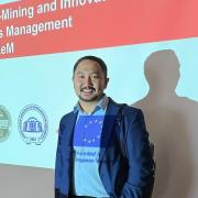
A great achievement of the Department of Surveying and Geodesy was won by the international ERASMUS project on the topic "Master Program in Eco-Mining and Innovative Natural Resources Management", where 22 partners from different countries participate, Orynbasarova E.O. is the project manager from Satbayev University, and K.B. Rysbekov is the project coordinator (the grant holder is the State University "Zhytomyr Polytechnic"). This important achievement has become a key moment in our commitment to the development of scientific research, as well as provided unique opportunities for the exchange of knowledge and experience with leading educational institutions around the world.
The Erasmus project provides unique opportunities for students and faculty of the department to participate in international exchange of experience, training and research. The project also aims to strengthen cooperation between universities and institutes in various countries, creating a platform for the exchange of best practices and methodologies in the field of Mining engineering.
As part of the Erasmus project, Associate Professor Toktarov A.A. made a trip to Dumlupinar University (Kutakhya, Turkey) as part of academic mobility. The experience and knowledge gained within the framework of the Erasmus project will become an important contribution to the educational process and scientific research, contributing to the additional development of the educational institution. It also opens up new opportunities for students, enriching their professional and personal growth, and strengthens the position of the department on the world stage of scientific and educational achievements.
https://eminrem.ztu.edu.ua/contacts/
Also, as part of our development strategy, we are proud to announce the conclusion of a cooperation agreement with the Czech Technical University. This important step not only opens up new perspectives for students studying "Geospatial Digital Engineering" (Geodesy), but also enriches the educational environment of our department.
From December 11 to 13, 2023, Head of the Department of Surveying and Geodesy Elmira Orynbasarova and teacher Alpysbai Marua took part in the 34th Geological Remote Sensing Group Annual Conference & AGM, which was held in London.
Our undergraduates had a unique opportunity to complete an internship at the Czech Technical University, which significantly expanded their professional experience and allowed them to deepen their knowledge in the field of geodesy. This valuable experience not only contributed to their education, but also facilitated the exchange of advanced technologies and methods in our industry.
Active participation in the academic mobility program allows our students to go to study at educational institutions in Poland, South Korea, Hungary, and Turkey, where they not only expand their knowledge, but also actively participate in the international educational environment.
Our international initiatives not only open up new horizons for students, but also strengthen our ties with leading universities abroad, facilitating the exchange of advanced research and educational practices.
In addition, it is important to note that the head of the department, E.O. Orynbasarova, in 2023, was sent to Bengaluru, India, to participate in a conference of young authors chaired by India within the framework of the Shanghai Cooperation Organization. This step demonstrates our commitment to represent the university and the department internationally.
In order to further enrich the educational environment and exchange academic experience, the department regularly invites outstanding foreign professors to give lectures. Among our honorary lecturers were such respected scientists as Dai Huayan, Wilhelm Stelling, Evgeny Levin, Peng Suping, and Roman Schultz. These lectures not only provide unique knowledge and experience, but also contribute to enriching the academic environment at the department.
We continue to actively develop our international partnerships in an effort to enrich the educational process and prepare our students for the challenges of the modern world.
Educational programs
-
Undergraduate
-
Graduate
-
PhD
-
Distance education